ENG
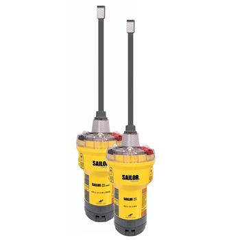
SAILOR 4065
The SAILOR 4065 EPIRB Emergency Beacon (Emergency Position-Indicating Radio Beacon) is a reliable device designed to alert search and rescue services in the event of an emergency on the water. This beacon provides fast and efficient transmission of coded distress signals at 406 MHz via satellite and ground stations, sending information to the nearest rescue coordination centers.
Key Features:
- Integrated GPS receiver: The GNSS model allows you to accurately determine the location of the buoy during search and rescue operations, which significantly speeds up the rescue process.
- Xenon flash: The bright flash provides visual identification of the device over long distances, making it easier to detect it in low visibility conditions.
- Durability: The device provides continuous operation for at least 48 hours, which guarantees its effectiveness in long-term rescue operations.
- Global support: The system operates within the Cospas-Sarsat satellite network, which provides coverage anywhere in the world.
- Compliance with standards: The SAILOR 4065 EPIRB complies with GMDSS international standards and IMO Resolution A810(19), which confirms its reliability and quality.
- Self-test function: The device is equipped with a self-test function that allows the user to check its operability before going to sea.
- Compact and lightweight hull: The design of the buoy provides ease and convenience in use, making it an ideal choice for vessels of all sizes.
The SAILOR 4065 EPIRB is an indispensable piece of equipment for ensuring safety on the water. Its robust features and ease of use make it an ideal choice for seafarers, providing confidence in emergency situations.
|
Specifications: |
|
| Frequencies: | 406.025MHz +/-1kHz и 121.5MHz +/- 3.5kHz |
| Output Power: | 5W |
| Weight: | 710g |
| Dimensions: | 425 x 105 x 105 mm |
| Message format: | MMSI / C/S / Serialised |
| Operating temperature: | -20°C to +55°C (Class 2) |
| Battery: | 5 years of storage or 48 hours of operation |
| Waterproof: | immersion to a depth of 10m |
| Frequency: | 406,025 MHz ± 1kHz |
| Output Power: | 5W |
Available for order
 Aids to Navigation
Navigation devices can be used to take measurements of objects indicated on the map

 +7 (812) 4-673-673
