 +7 (812) 4-673-673
Furuno Augmented Reality Navigation System
MOL Introduces Dubai's Enhanced Augmented Reality Navigation System
Mitsui OSK Lines, Ltd. (MOL) announced that together with Furuno Electric Co., Ltd. they unveiled their advanced Augmented Reality (AR) navigation system at the OCIMF Middle East Regional Maritime Forum, held in Dubai in September.
The presentation outlined the basics of technology and system development, as well as MOL’s efforts “to move forward to become a world leader in safe navigation”.
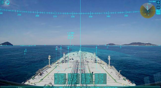
The AR navigation system provides visual support to crew members during their observation and ship operations using AR technology to overlay real-time flight information video images.
Large tankers with deep draft * require very careful management in waters such as the Strait of Malacca, on heavily congested shipping lanes. If a collision occurs or the ship runs aground, this can lead to an oil spill and a serious environmental disaster.
* The vertical distance between the bottom of the hull and the waterline.
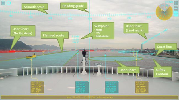
AR navigation system can display combined video images in real time and information about the ship's heading from navigation devices on the bridge display even on congested sea routes. This allows seafarers to ensure that they are on a safe course, warns them of neighboring vessels that may be at risk, shows shallow areas and other potential dangers.
The presentation aroused great interest among the representatives of the tanker industry who attended the conference. Using the feedback received at the conference, MOL will continue to work closely with FURUNO to explore further system upgrades to ensure that the AR navigation system contributes to maritime safety “through the eyes of captains and officers” who will use the system on board and offer user support.
** ENOC Maritime Conference and OCIMF Middle East Regional Maritime Forum. It was held in the UAE from September 10 to 11, 2019 by the UAE National Oil Company (ENOC) and the International Marine Forum of the Oil Company (OCIMF).
** The system displays on tablets and screens information about other vessels sailing along the planned route of the vessel and its surrounding marine areas and other conditions, such as shallow water. It combines information from an automatic identification system (AIS) and radar with real-time video from a bridge camera, combined with the latest FURUNO series for displaying electronic cards and information (ECDIS) of the FMD3300 series.