ENG
Samyung N500R

The Samyung N500R is a universal marine navigation device that combines the functions of a GPS receiver and a chartplotter. This device is able to synchronize with various external systems via the NMEA0183 interface, providing up-to-date location information. A distinctive feature of the Samyung N500R is its compactness and lightness, as well as the presence of a 5-inch color TFT display, compatibility with NAVIONICS cards on Micro SD cards.
Features of the Samyung N500R Chartplotter
The N500R GPS receiver, designed for maritime navigation, is optimized for use on ships reaching speeds of up to 70 knots. The device has the function of instant fixation of coordinates in the event of a person falling overboard. The receiver's display allows the user to adjust the brightness level, select the background color scheme and switch to Night mode. The maps used in the Samyung N500R contain all the necessary information for navigation, including the designations of buoys, lighthouses, underwater cables, depth gauge data, yacht parking and much more.
Technical specifications:
- Display: 5-inch, color TFT, 800x480 pixels resolution;
- Power supply: voltage from 10 to 34 volts DC;
- Operating temperature: from -10 to +50 degrees Celsius;
- Card carrier: Micro CD card;
- Supported maps: NAVIONICS, C-MAP max;
- Communication protocol: NMEA 0183;
- Waypoints: up to 10,000, with the ability to enter names up to 8 characters;
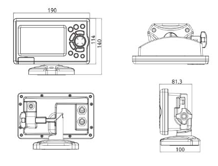
- Dimensions: 190 mm (width) x 140 mm (height) x 100 mm (depth).
Certificate:
-
RMRS
Available for order
Certificates:
Documentation:
 Steering Gear Interface NAVIPILOT 4000+ / NAVIGUIDE 4000
Equipment and Accessories
 +7 (812) 4-673-673