 +7 (812) 4-673-673
Communication systems. Ship - shore
Communication between ship and shore and between ships and ships GMDSS stands for Global Maritime Distress and Safety System.
It makes use of the satellite communications now available through the international maritime satellite INMARSAT system. INMARSAT is a co-operative organisation, which includes about sixty countries, which fund and take compensation according to each member's use of the system. Geostationary satellites are positioned about 36,000 kilometres over the equator to provide nearly complete global coverage.
The system provides automatic communications with an override facility for distress calls. Several service standards are provided. INMARSAT В and C have a distress alerting facility at the press of a button.
Areas served by VHF shore stations are called Al and areas served by MF/HF shore stations are called A2.
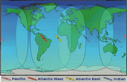
Satellite coverage around the world
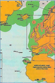
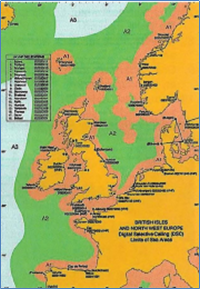
Charts showing Al and A2 around the North Sea and the East Atlantic coast. These charts are available for all parts of the seas.
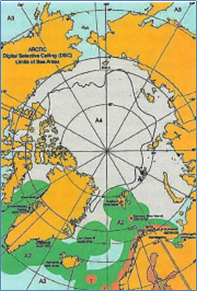
The Atlantic falls primarily in area A3 and north of the Atlantic in the polar area A4
The four GMDSS sea areas are designated Al, A2, A3 and A4:
- Sea Area Al means radio coverage of at least one VHF coastal station in which continuous DSC alerting is available. In principle, this is within 20 miles from the coast of populated areas.
- Sea Area A2 means within radio coverage of at least one MF coastal station in which continuous DSC alerting is available. Range about 40 miles from the coast of populated areas.
- Sea Area A3 includes the rest of the seas within reach of an INMARSAT stationary satellite in which continuous alerting is available.
- Sea Area A4 means all areas outside Al, A2 and A3, which in practice means the polar regions of the Arctic and Antarctic.
The satellites are located above the equator and cover the earth from 70° South to 70° North. is worldwide standardised in the GMDSS system. The international Maritime Organisation, IMO , is the regulating body.
For the coastal areas, the requirements depend on the capabilities of the coastal stations. Large unoccupied coastal areas have no coastal stations so that equipment for area A3 has to provide communication in those areas.