Navigational information about local waters

16.12.2021

Navigational information about local waters

When the Navigator is appraising his passage plan, he/she should be prepared to look for the relevant information in the appropriate reference books. The British "Pilot Books" cover the entire globe in 72 volumes. The electronic version is called e-NP (Nautical Publication). All sorts of information can be collated, stored digitally and presented in an appropriate manner as needed on an electronic chart. Never the less, these charts still don 't contain so much information as to make Pilot Books/eNP superfluous: they should still be consulted.

Extract from the American “Coast Pilot”: The topics in the Coast Pilot include, but are not limited to, channel descriptions, anchorages, bridges, prominent features, pilotage, towage, weather, ice conditions, wharf descriptions, dangers, routes, traffic separation schemes, small-craft facilities , and Federal regulations applicable to navigation. The American Coast Pilot is available on the Internet.

Navigational information about local waters

In a privately-published sailing directions, one can find the following informative text about Rio Gallegos in Patagonia:

Remarks: this harbour is one of the most ifficult to access along the whole Patagonian coast, due to the huge tide range (10,9 m at spring), the related 6-knot streams and the many shifting sandbanks in the entrance. After talking with the very few skippers w ho, for one reason or another (mostly emergency) entered the harbour, we came to the conclusion that heaving-to out at sea is more desirable by far than risking to run aground on one of the wide sand banks encumbering the entrance. A low-powered vessel finds it difficult to follow the many leading ranges in the strong winds and fast streams of the area. Furthermore, once past the obstacles, the vessel remains subject to the power of winds and currents even inside the river... Good to know in advance!
Information about lights is to be found in the List of Lights  published by Britain and the USA. The American version is available on the Internet.  Tide tables and tidal stream charts are issued by countries with tidal waters.
The Amirality List of Radio Signals gives a description of all forms of radio signals in six volumes:
  • NP281 (Parts 1 & 2) - Maritime Radio Stations
  • NP282 - Radio Aids to Navigation, Satellite Navigation Systems, Differential GNSS (DGNSS) Legal Time, Radio Time Signals and Electronic Position  Fixing Systems
  • NP283 (Parts 1 & 2) - Maritime Safety Information Services
  • NP284 - Meteorological Observations Stations
  • NP285 - Global Maritime Distress and Safety System (GMDSS)
  • NP286 (Parts 1- 7) Pilot Services, Vessel Traffic Services and Port Operations

Navigational information about local waters      Navigational information about local waters

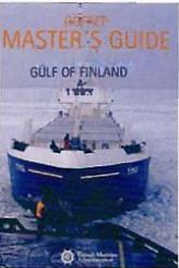
Navigational handbooks common'y set out traffic rules, but one can aho encounter special publications such as this one from Finlan

Navigational information about local waters Navigational information about local waters

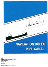
Regulations for the Kiel Canal in pdf format, downloaded frum the Interne


Иностранный язык:  en

Back to the list