 +7 (812) 4-673-673
Correcting electronic charts
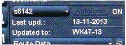
An information window on the screen with correction information about the current electronic chart
When new corrections are entered in an ECDIS there is an automatic control function to check that earlier corrections have been entered. If a correction is missing then ECDIS: will raise an alarm and it will not be possible to continue until the missing correction has been entered.
When ROCKNES went aground 040119 in Vatlestraumen in Norway, the pilot and the captain were both familiar with the waters but they were using unofficial electronic charts. A new paper chart, corrected in February 2003, was available on board, but it was not consulted. The official electronic chart (for ECDIS) that had been issued at the time was also corrected for the shoal.
Unofficial electronic charts have varying periods between corrections. The corrections are carried out by exchanging the old memory card for a new one, which is supplied at a discount.An updated memory stick may require a software update!
In raster electronic charts the corrections are in another data-layer. Some of them can also be corrected automatically.
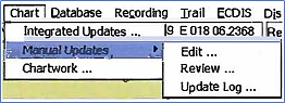
1.1. Manual corrections
Manual corrections can be carried out on ENC s using information from NtM.
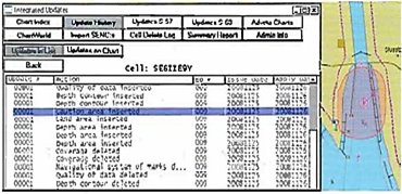
Correction log (Adveto) Menus for manual corrections. A log of manual corrections can also be accessed
|
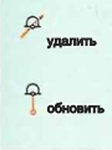
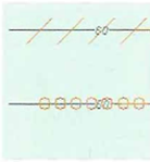
Single objects that have been removed crossed out by |
Line features that have been removed are crossed out and when added marked by a series of small red circles |
Added areas are marked by small red rings and |
General electronic chart functions
1. Panning
he small displayed area of an electronic chart on a monitor, as compared to a paper chart, requires the Navigator to move (pan) the chart picture, for example to view conditions some distance ahead of the vessel, or to increase the legibility of details (zoom).
Electronic charts can be panned in several ways:
- With the arrow keypads
- Shift the cursor to the margin
- Centre on the cursor by changing scale
- Moving the vessel to the screen centre by a single keypad command
- Automatic panning during True Motion can be activated so that the image area displayed in front of the vessel symbol will not be too little.
2. Changing scale
Coastal navigation, particularly in restricted waters, may require frequent scale changes.
Different manufacturers do this in different ways:
- Right- or left-keypads
- A button on a control unit
- An icon on the ribbon
- Scale changes that download another cell can make significant changes to the image
- Scale changes inside a cell may alter the information displayed if the SCAMIN-attribute boundary is exceeded for a specific symbol.
The ECDIS standard permits the inclusion of nautical information from for example Pilot books, to be included in the system as additional layers, but the flag state must approve the use.
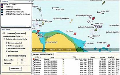
AIO, Admiralty Information Overlay, is another way to include the presentation of more information by ENCs. AIO includes all UKHO Temporary and Preliminary Notices to Mariners and other news items that have not yet been issued as corrections. More information about AIO can be found on the UKHO website: www.ukho.gov.uk The Admiralty e-navigational Planning Station can show all the UKHO digital publications as overlays on their electronic charts, (AVCS and ARCS).
 Admiralty Total Tide as an overlay