 +7 (812) 4-673-673
Automatic Identification System
AIS (Automatic Identification System) is a transponder system created originally to improve information for safer -avigation and so decreasing the risk of collisions. This is “ecessary because, for example, radar cannot show vessels hidden by islands and bends in rivers. By transmitting the call sign of the vessel and providing the name of the vessel in the transmission, AIS also enables directed communication with a specific vessel by VHF.
However AIS is being developed further and further to provide ever more information. This is transmitted on the VHF-band and requires special equipment, which is manufactured in three classes:
- Class A transmitter and receiver for commercial shipping
- Class B transmitter and receiver for recreational vessels
- Receiver
 Courtesy IALA
AIS information is also transmitted over the Internet, so an on-line surf tablet can show AIS information.
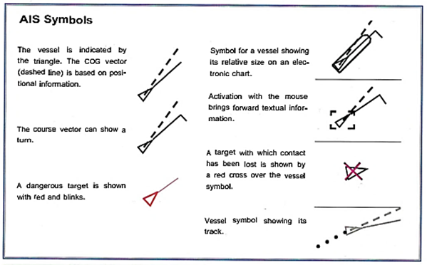
 AIS-Hst and symbols in an electronic chart
 Radar with AIS overlay, so the AIS symbols can be seen together with the radar contacts
SOLAS regulations specify that the following vessels shall have AIS:
- All vessels of 300 gross tons or greater, in international traffic.
- Merchant vessels of 500 gross tons or greater that are not engaged in international traffic
- All passenger vessels regardless of size.
 Operator unit for AIS
 AIS gives three categories of data^
1. Static data
- IMO number
- Call sign and name
- Length and breadth
- Type of vessel
- The placement of the antenna for position reporting.
- Positional information with level of accuracy
- Time in UTC
- Course over ground
- Speed over ground
- Steered course
- Voyage status ("anchored", "breakdown")
- Turning rate (if available)
- Draft
- Dangerous cargo
- Destination and ETA
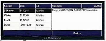
- Safety-related information (if necessary)
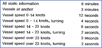
The risk with AIS is that not all vessels carry AIS. Also the B transmitter uses "old" information as it transmits only once every 30 seconds. Furthermore B transmissions can be filtered out.
The AIS system can create virtual navigational marks, which is useful for urgent jobs, such as marking a wreck, or when a physical mark isn't possible. This function is also useful when conditions are changeable, such as in canals, rivers, height obstacles and ice. It can also be used to transmit weather information.

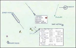
 AIS-information in a navigational system
It is generally concidered that AIS should not normally be used as the sole means of determining risk of collision.
|
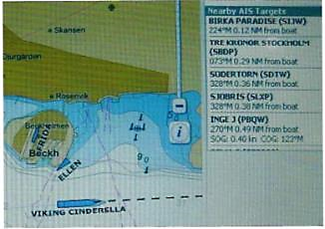
Electronic chart with various AIS symbols |
Like most systems, AIS can also have its bad times! |
The piIot can assist by providing correct local information, such as how a specific turn should be made by a vessel of a given size and contact with the VTS about meetings. The pilot also brings up-to-date information about navigational marks and depth changes depths, detailed knowledge of the state of the tide, his/her own system of marks for courses and turns, conditions at tie quay, etc. The legal requirement for a pilot varies between different countries and waters.
Cooperation between pilot and captain is not always cloudless. There are many examples of poor relationships and collaboration. In addition, the pilot may run aground and is not a guarantee of safe passage.
Even with a pilot on board the captain and the OOW are respon sible for the safe conduct of the vessel. Examples of undefined responsibilities leading to mistakes are legion. Even though in practise the pilot will be the most active, the Navigator must check that another person's mistake doesn't lead to negative consequences!
A number or reports on the Internet illustrate the sort of problems that can occur during pilotage: CRETE CEMENT, SILJA OPERA, RAVEN ARROW,COSCO BUSAN, FRANCOISE GUILOT.
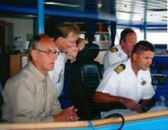
 Photo Gerry Wirf