 +7 (812) 4-673-673
Networks
24.12.2021
In a chain net the units are connected serially, i.e. one after the other. This is an uncomplicated network but large parts of it can be knocked out by a simple break in a cable. It is not uncommon for the parts of a navigational system network to be connected in different ways. In the diagram below each sensor is connected to its own display unit and processor, and these units are then connected serially in a chain.
The advantages of this topology are flexibility and insensitivity to heavy traffic in one node, as this will not affect the others. Nor will a single cable rupture take down the entire network.
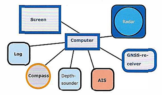
A disadvantage of the star network is that there is no redundancy. A fault in the central node, which is usually a computer, will knock out the entire network.
It is easy to add in more computers to such a system. However the risk of incompatibility is considerably greater if several computers are connected.
In practise it is common to encounter navigational systems with connections that are a combination of chain, bus and star networks.
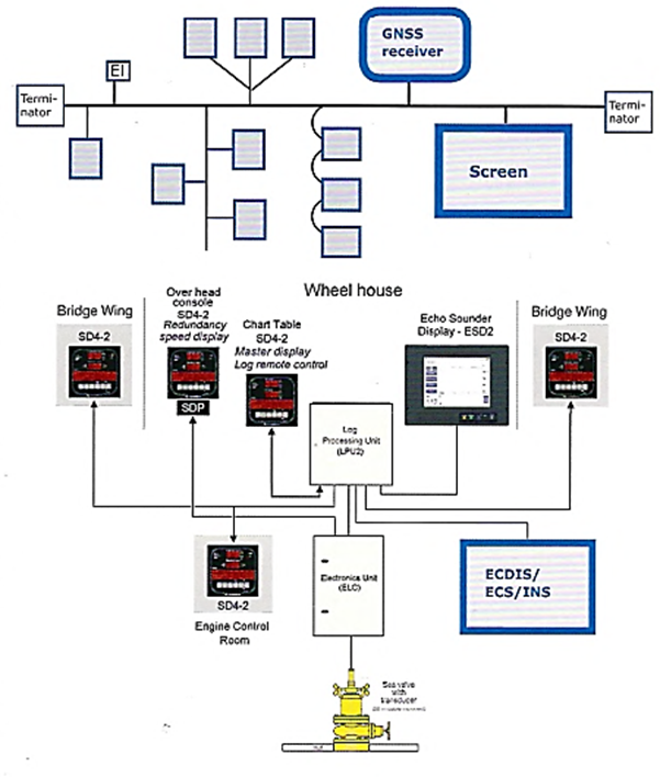
A sub-network, consisting for example of log, may be part of a larger network, as for example the SAL log in the diagram to the right.
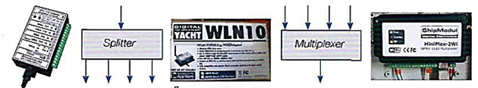
Multiplexers in a network combine data from several sources to a single data stream and Splitters copy a signal to several display units.
Networks may also use adaptors for local wireless networks so that data can be shared on many screens at different locations on the ship.
l.lThe primary function of the ECDIS is to contribute to safe navigation
1.6 ECDIS should reduce the navigational workload compared to using the paper chart. It should enable the mariner to execute in a convenient and timely manner all route planning, route monitoring and positioning currently performed on paper charts. It should be capable of continuously plotting the ship’s position.
3.1 Electronic Chart Display and Information System (ECDIS) means a navigation information system which with adequate back-up arrangements can be accepted as complying with the up-to-date chart required by regulations V/19 and V/27 of the 1974 SOFAS Convention, as amended, by displaying selected information from a system electronic navigational chart (SENC) with positional information from navigation sensors to assist the mariner in route planning and route monitoring, and if required display additional navigationrelated information. (MCS 232)
ECDIS consists of a computer, a position source (GNSS), electronic charts and a navigation program. Radar and other navigational information may be added, providing this does not degrade the information on the screen.
The minimum requirements of an ECDIS system is connections between the following components:
The standards for ECDIS can be found in the IMO Resolution A.817 + MCS 232 and the International Electrotechnical Commission IEC 61174.
n order to be certified an ECDIS must meet several further conditions:
In addition to these international requirements the flag state may have addition requirements. Finally membership of organisations, such as for oil transportation, may add further regulations.
A number of conditions must be fulfilled if a network of navigational instruments will work properly:
- The instruments must be able to communicate with each other. Signals from sensors can have different formats (analogue, digital and video) and speed (baud rate). This is managed by system settings.
- The connections must be resistant to damage from heat, water and vibrations. Both standardised and manufacturer-specific connectors can be encountered.
- Reliable electrical supply.
Connections
Different parts of the system may use different types of connectors, or may be coupled in different ways.In a chain net the units are connected serially, i.e. one after the other. This is an uncomplicated network but large parts of it can be knocked out by a simple break in a cable. It is not uncommon for the parts of a navigational system network to be connected in different ways. In the diagram below each sensor is connected to its own display unit and processor, and these units are then connected serially in a chain.
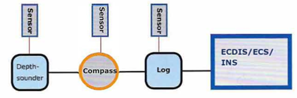
A serial array of units, each with its own sensor
In its simplest form a star network consists of a central connector unit to which all the instruments are coupled.
The advantages of this topology are flexibility and insensitivity to heavy traffic in one node, as this will not affect the others. Nor will a single cable rupture take down the entire network.
A disadvantage of the star network is that there is no redundancy. A fault in the central node, which is usually a computer, will knock out the entire network.
A bus network means that all the instruments are coupled to a central bus (cable) for both data and current, with terminators at both ends.
It is easy to add in more computers to such a system. However the risk of incompatibility is considerably greater if several computers are connected.
In practise it is common to encounter navigational systems with connections that are a combination of chain, bus and star networks.
A sub-network, consisting for example of log, may be part of a larger network, as for example the SAL log in the diagram to the right.
Multiplexers in a network combine data from several sources to a single data stream and Splitters copy a signal to several display units.
Networks may also use adaptors for local wireless networks so that data can be shared on many screens at different locations on the ship.
Local wireless network. (LAN)
ECDIS
Taken from the ECDIS standard (IMO Resolution A.817)
1 SCOPE OF ECDIS
l.lThe primary function of the ECDIS is to contribute to safe navigation
1.6 ECDIS should reduce the navigational workload compared to using the paper chart. It should enable the mariner to execute in a convenient and timely manner all route planning, route monitoring and positioning currently performed on paper charts. It should be capable of continuously plotting the ship’s position.
3.1 Electronic Chart Display and Information System (ECDIS) means a navigation information system which with adequate back-up arrangements can be accepted as complying with the up-to-date chart required by regulations V/19 and V/27 of the 1974 SOFAS Convention, as amended, by displaying selected information from a system electronic navigational chart (SENC) with positional information from navigation sensors to assist the mariner in route planning and route monitoring, and if required display additional navigationrelated information. (MCS 232)
ECDIS consists of a computer, a position source (GNSS), electronic charts and a navigation program. Radar and other navigational information may be added, providing this does not degrade the information on the screen.
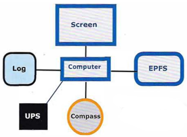
The minimum requirements of an ECDIS system is connections between the following components:
- A computer equipped with a navigation program and electronic charts.
- A continuous source of positions, EPFS = Electronic Position Fixing System
- Compass
- Speed log
Minimum requirements for ECDIS
- Show all chart information that is necessary for safe navigation
- Use electronic charts published by official chart producers.
- Contain a method for the simple and secure correcting of electronic charts and other information.
- Result in simpler navigational procedures than the corresponding routines using paper charts.
- Have at least the same reliability and accessibility as paper charts.
- Make route planning easier, continuously show the route and the position of the vessel, permit routes and waypoints to be easily altered and shall sound an alarm if the ship makes a large departure from the route.
- Deliver positions based on systems in continuous operation and sound an alarm if signals are missing.
- Display an error message when the system is used incorrectly or when equipment is not working properly.
- Be equipped with on board testing routines which will indicate the location of any fault that should occur.
- Be possible for the Navigator to plot and read latitude and longitude on the screen, as well offering the availability of electronic bearing lines, variable and fixed range rings and movable icons for points and other objects that are necessary for navigation.
- Be possible for the Navigator to easily add or remove information from the screen.
- Be impossible for the Navigator to remove information from the electronic chart or the database.
- Be possible for the Navigator to set a safety contour and/or a safety depth and the system shall sound an alarm if these are exceeded.
The standards for ECDIS can be found in the IMO Resolution A.817 + MCS 232 and the International Electrotechnical Commission IEC 61174.
n order to be certified an ECDIS must meet several further conditions:
- Fulfil the ECDIS Performance Standards
- Contain up-to-date ECDIS software
- Use up-to-date official vector charts (ENCs)
- Use type-approved software and hardware components
In addition to these international requirements the flag state may have addition requirements. Finally membership of organisations, such as for oil transportation, may add further regulations.