 +7 (812) 4-673-673
Errors and idiosyncrasies related to electronic chart
- If the electronic chart uses another coordinate system than GNSS-positions (in WGS 84) then the position of the vessel symbol will be wrong.
- Errors due to vectorisation.
- Compatibility errors. The image of a vector electronic chart requires the cooperation of: electronic chart, system program, Presentation library and setting in the system. Examples of incorrect functioning are known as a result of inadequacies in that cooperation, for example, when the program version is changed.
- The image of a raster chart is determined by the original paper chart. Past a certain level of zoom, no additional information is added to the image.
- The image of a vector chart is determined by the vectorisation process and by the programming. From a certain level of zoom no new information will be added in a cell. Over-zooming may make the image easier to read but it will also magnify positional errors, just as in a raster chart. On the other hand, the Navigator must use a certain level of zoom in order to bring forward all necessary information. If a more legible cell is not available then zooming in will not make the information more legible.
- Neither raster nor vector charts can be better than the information on which they are based. This may often consist of old nautical surveys. One cannot expect that the shoreline is more accurate than +/- 10 meters, or that depth contours are absolutely accurate. Indeed, these are normally drawn by interpolating between the depths measured by echo-sounding.
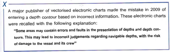
In order to keep an overview and see interesting details the Navigator must be active in his use of scale changes and panning. An alternative solution is to use a split screen.
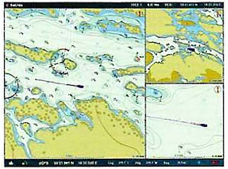
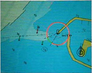
The red arrow marks a coordinate error in a harbour special from a privately-published electronic chart The electronic chart at a small scale that covers this area has the correct coordinates. The data come from different sources
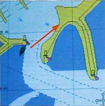
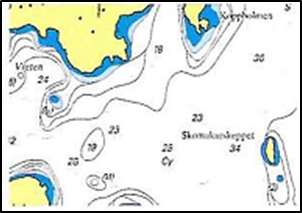
During vectorisation one of the spars in the entrance has been given the wrong colour! An example of the sort of error that can happen
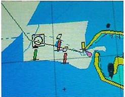
An unofficial electronic chart, although based on 5-57 data. These charts are increasingly common and can be found in surf tablets and mobile phones. S-57 stops this kind of error c/ccping in as a result of the "human factorThe sharp bends in the depth contour is a result of all of the survey data not having the same geographical coordinates
 More zoom - more information
ENC vectorization is governed by S-57 specifications. Privately published vector maps are governed by internal rules about which features should be displayed. They can be handled differently by different navigation software and plotters. The navigator should familiarize himself with his electronic maps in order, as far as possible, to study their features.
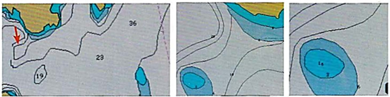
Compare the map image below with the image above
|
The shoal is not displayed, The skerry is not displayed |
The shoal and the 3-metre contour are displayed |
The least depth is displayed |
Ur: SN.l/Circ.312 9 July 2012 frail IMO
Small (point) land areas, especially those depicted only on small scale (usage band 1 and 2) ENCs may not always be clearly displayed and do not always activate alarms in route planning or route monitoring modes in some ECDIS equipment: (a) it is possible for small land features to be obscured by other chart detail such as names or contour labels; and
Due to the limitations of ECDIS referred to in 5(a) above, mariners (even those using the most modern systems) should always undertake careful visual inspection of the entire planned route using the’’Other/ All” display mode to confirm that it, and any deviations from it, are clear of dangers.
Text of NAVAREA1 317/10 Recent preliminary investigation indicates that some ECDIS may not display certain combinations of chart features and attributes correctly and on rare occasions may fail to display a navigationallv significant feature. This appears to be caused by anomalous behaviour in some ECDIS software, especially early versions. The existence of such anomalies highlights the importance of maintaining ECDIS software to ensure that
operational capability1 and reliability are maintained. It is recommended that appropriate checks are made with the equipment manufacturer. This is of particular importance where ECDIS is the only source of chart information available to the mariner The International Hydrographic Organization (IHO) is investigating these matters in consultation with ECDIS equipment manufacturers. Further information will be made available through Notices to Mariners and within the UK element of the README.TXT Tile included on ENC service media.