 +7 (812) 4-673-673
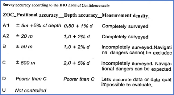
Chart data
The map is the result of many individual surveying processes (depths and coastlines) carried out by national authorities or private enterprises. After that, it is necessary to collect information about land and navigation.
All of this is collated by the cartographer to create a map at a suitable scale for the intended use. Physically, maps can be printed or saved as an electronic map.
1. Hydrographic surveys
Hydrographic surveys are conducted using the best positioning technology available. Older surveys provided less precision than navigators of the time could achieve. Since the introduction of DGNSS (a more precise type of GNSS, see page 96), vessels can navigate with almost the same accuracy as new measurements. However, these new measurement data are currently not available for all waters. As a result, in many situations, ships navigate with a higher degree of positioning accuracy than the charts they use.
Some sources of geodetic errors are:
- Measured depth / elevation / shoreline is incorrect.
- The depth at this position is not measured correctly (tide height) or has changed.
- The measurements are taken at such a great distance from each other that some details are not detected.
The quality of geodetic work has improved over the years by several levels. Progress in the field of geodesy in different countries, in fact, follows the same pattern.
Until 1930, surveying was done using manual measurements. When a sandbank was found, it was thoroughly surveyed and mechanically checked to the smallest depth (sweeping). In some cases, shoals that were not detected during the survey were not detected until vessels with a higher draft entered the area. The number of site depth measurements is an indicator of the quality of the survey and all depth surveys prior to 1930 should be considered unreliable. Depths measured with a hand weight usually overestimate true depths by 4-5%.
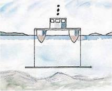 Mechanical control, "sweeping"
Between 1930 and 1940 the use of echo-sounders was introduced. Every reflected sound pulse is registered by a blinking light on a depth scale. Later on recording echosounders became the norm.
Positions were still measured optically, using horizontal angle measurement. Around 1950 it became possible to use electronic position fixing. Such measurements were densely distributed along the course of the measuring vessel but were still not always enough. Depths measured by echosounder are generally underestimates as the instrument tends to use the first returned signal and this may not be directly below the sensor.
From a range of different methods, used by different countries, from the mid-1990s the favoured method became the "Multibeam echo-sounder", which allows a single vessel to measure a swathe whose breadth is more than 3.5 times the depth.
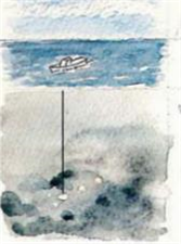
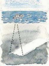
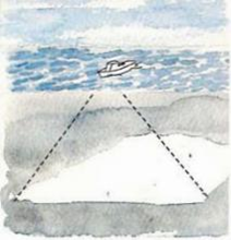
|
A hand lead will only measure where it hits the bottom |
Cor tinuous echo-sounding requites several passes in order to create full co /erage |
The multi-beam echo-sounder measures a broad swathe with full coverage. The raw data are then processed by a variety of programs |
The next step after the survey was to evaluate the measurements (the echogram) and produce charts at a large scale, in which representative depths were entered and depth contours plotted. This was all manual work until the introduction of electronic recording devices. These are capable of collating digital depth measurements with electronically-determined positions so almost all evaluations are performed automatically.
Modern charts may contain data digitised from old charts along with data from more recent, completely computerised surveys. These days new measurements are immediately checked on board the survey vessel an those which are obviously measurement errors are.discarded.
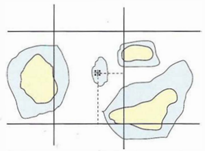
The seriousness of positional inaccuracies depends on the navigational method in use. For satellite navigation it is important that depths are given their correct coordinates. For optical and radar navigation it is important that depths are correct in relation to navigational marks and to the coastline - used for position estimation. In some regions, such as the Caribbean, the Pacific and around Greenland it is still possible to encounter islands with unknown coordinates. Under these circumstances radar navigation (relative navigation) is more reliable than satellite navigation.
|
Modem sea survey with shorelines ar.d shoals positioned using satellite navigation system in the WGS 84 koordinate system |
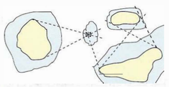
In old sea survey; shorelines and shoals were positioned in relationship to each other. When such old data are incorporated in new charts or electronic charts, it will not always be in the correct WGS S4 positions. So satellite navigation may encounter problems, but radar navigation using range and bearing measurement will work within such an area |
The quality of optical position surveys was adequate as long as the charts were used for optical navigation. That is to say, coasts, shoals and marks had correct local positions in relation to each other. When older data is incorporated into electronic charts it has to be corrected to WGS-84 coordinates in order to work properly.
A position that is inaccurate is more serious than an incorrect depth sounding, because a navigator should be more inclined to go around a shoal than to intentionally sail over it.
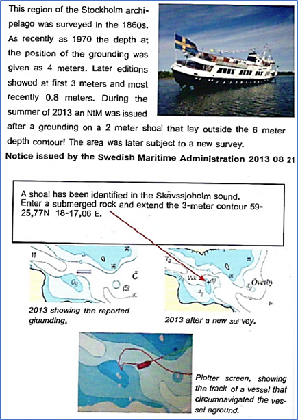
Occasional shoals have been found by vessels running aground or having a contact with the sea floor. This tends to prompt a new survey. None the less, the risk of undiscovered shoals and 3-meter contours with inaccuracies cannot be entirely discounted. In some countries (not UKHO charts) channels with the most reliable survey data may be marked with grey.
On the high seas the best surveys are concentrated to heavily used traffic lanes, which are shown on the chart.
|
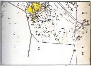
ZOC diagram on a Finnish chart |
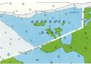
Different measurements sets that don't join properly. From a British chart in an area outside the channel (2008) |
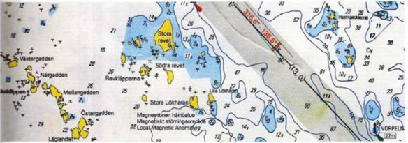
A detail from a Finnish chart. The grey rastered area in the channel represents the highest quality of measurement, with the minimum depth specified. Outside the channel the quality of measurements vary
3. Corrections
SOLAS_V/27
Nautical charts and nautical publications, such as sailing directions, lists of lights, notices to mariners, tide tables and all other nautical publications necessary for the indeed voyage, shall be adequate and up to date.
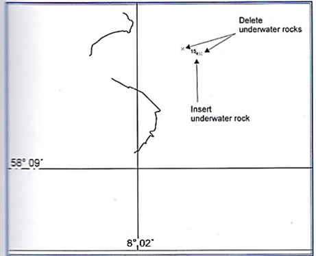
New shoals are discovered by hydrographic survey and occasionally by accidents. In some areas, such as estuaries with changing sandbanks, bottom conditions are constantly altering. Changes are also ordered by the responsible authorities: lights are withdrawn from service, areas are dredged or filled in, piers are built, etc. There is also a continual stream of new regulations, at both local and international levels. For these reasons all national chart publishers also issue corrections of their charts.
Most changes are permanent but some are only temporary (T-notices) and are applicable for a defined period. P-notices are advance warnings of planned alterations.
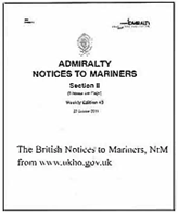
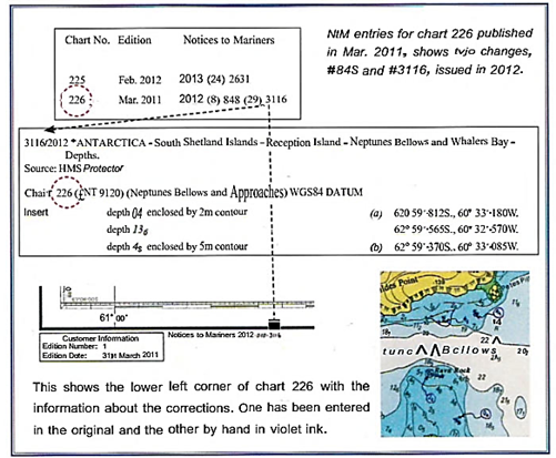
Correcting charts is an unavoidable issue for the Navigator. Traditionally charts were corrected manually. British charts are corrected on the basis of information provided by weekly "Notices to Mariners (NtM), which can be found both on the Hydrographic Office (UKHO) website and in a printed version.
The UKHO has an extensive organisation to manage corrections from all over the globe. The information, for example a harbour extension, has to be passed by the contractor to the national authority, from there to UKHO which then has to incorporate the information in the NtM, which in turn has to reach individual vessels. Finally someone has to make the correction on the chart!
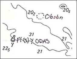
Violet ink is the traditional way to enter a manual correction
The so-called tracing, a transparent matrix that makes corrections easier. (Norwegian Hydrographic Service)
Charts can also be corrected with a "block", which is a piece of a newly-printed chart which can be cut outand glued onto the chart in the right position
To check to what extent the UK map has been corrected, the navigator should download the General List from the UKHO website. For instance:
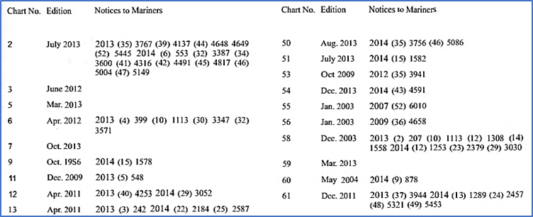
Extract from the UKHO Cumulative list which describes which notices apply to which charts
Omitted Correction
The captain of a vessel leaving a Swedish harbour decided not to use a pilot, in spite of the fact that he was not familiar with the harbour in question. The vessel was not required to use a pilot. The chart used was a newly-issued British one. A breakwater on the chart was shown as under construction, i.e. according to the chart the breakwater was not finished. The captain's intention was to exit the harbour using only optical navigation methods. In actual fact the breakwater had been completed several years ago. Having left the inner harbour, the captain became confused because what he saw was not what he expected to see. In the short time available he was not able to fix either his position or the turning point with another method and the ship ended up aground. A contributing factor was that the low elevation of the sun, which was shining into his eyes. The enquiry showed that for some reason the British chart publisher had not incorporated the relevant NtM notice regarding the completion of the breakwater. (Swedish Maritime Administration report OOSTERBRUG 2003).
4. The chart and reality
Improvements in surveying methods mean that newer editions of charts are more reliable than older ones. Cost efficiency dictates that resources tend to be concentrated around channels with busy traffic.
UNCHARTED DANGERS: Mariners are warned to exercise caution when using this chart as uncharted dangers may exist due to inadequate depth information (notice on a British chart).
- How well it is kept up-to-date by on-board corrections
- Sea level and tidal conditions
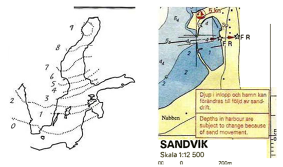
- Sedimentation outside rivers and harbour entrances affects depth. Dramatic depth changes may be experienced in regions of volcanic activity.
- Waters influenced by ice-caps are subject to sea-floor elevation, so actual depths are less than those given on the chart until corrected in a later edition.
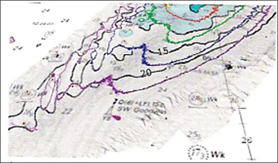
A new survey showing how the Long Sand Head sandbank near Dover is moving in a south-westerly direction, ,Vew curves (violet = 2C m, blue = 15 m, green = 10 m, red = 6 m and yellow = 3 m). Compare these to the older contours in black. (From NNT NetSurvey Ltd.)
It is almost a truism that the increase of traffic with vessels of greater draft has led to improvements in charts. The following example is a clear demonstration of the fact that even newly-produced charts, whether printed or electronic charts, which look up-todate, may still be based on older measurements which can result in surprises.
Land elevation rates in the Baltic, mm/year. This is the consequence of the glaciation 10000 years ago.
Comments i Gard News Issue 177, Feb/Apr 2005 claims, after a grounding with pilot onboard. “ Subsequent survey has revealed that the dredged channel was in some places 2.8 meters shallower than the charted depth.“
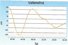
Water level variation in a tideless region. In this case the water level is subject to non-predictable variations based on a number of factors, such as wind direction and air pie- jre. From the Swedish Maritime administration "Vivakarta" on the Internet
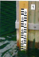 Water level gauge on a quay