 +7 (812) 4-673-673
The Long Range Tracking and Identification (LRIT) System:
28.11.2019
LRIT has been officially registered since January 2008, i.e. ships that were built after December 31, 2008 were to have this system.

LRIT was developed in accordance with the recommendations of one of the resolutions of the Maritime Safety Committee (MSC). This was done so that countries covered by the SOLAS Convention could exchange the necessary information on the maritime safety of ships that cross the coastal borders of countries.
The ship tracking system does not confuse the existing UNCLOS, nor does it interfere with the individual maritime operating laws of the countries where applicable.
According to the requirements of LRIT, ships that fall within its competence:
There are many countries that have included a ship tracking system as part of their ocean operations:
Long-term tracking and identification technology can successfully eliminate all undesirable and problematic factors in offshore production lines.
System identification and tracking of the long-range (LRIT)
Long Range Ship Identification and Tracking (LRIT) is an international tracking and identification system.LRIT has been officially registered since January 2008, i.e. ships that were built after December 31, 2008 were to have this system.
LRIT was developed in accordance with the recommendations of one of the resolutions of the Maritime Safety Committee (MSC). This was done so that countries covered by the SOLAS Convention could exchange the necessary information on the maritime safety of ships that cross the coastal borders of countries.
The ship tracking system does not confuse the existing UNCLOS, nor does it interfere with the individual maritime operating laws of the countries where applicable.
According to the requirements of LRIT, ships that fall within its competence:
- All vessels used for passenger transportation.
- All offshore drilling rigs that are used for offshore oil drilling.
- All vessels that are used for the carriage of goods. This criterion also includes faster vessels, as well as vessels weighing more than 300 gross tons.
There are many countries that have included a ship tracking system as part of their ocean operations:
- The largest number of vessels that installed the LRIT system is registered in the Panama Flag Register - about 8,000 vessels.
- The European Union adopted a ship tracking system in 2007
- Canada became the first SOLAS country to include a ship tracking system in 2009, followed by the United States the same year.
- Among the countries of South America, Brazil, Venezuela, Chile and Ecuador were among the leaders who adopted this system. Ecuador was the last among the four countries that adopted the system in 2010.
- Transmitter for sending information data
- Specific providers for this type of communication service. One such service provider is Absolute Maritime Tracking Services, Inc. (AMTS) established by the Panama Flag Register. This service provider is the only service provider for ships that are subject to Panamanian registration.
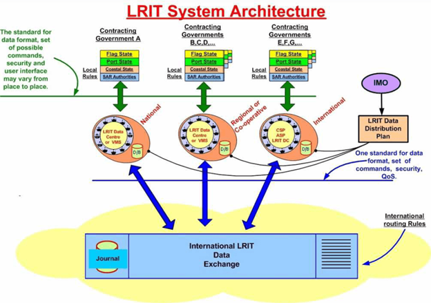
- System Data Centers
- Service Providers for General System Applications
- A thorough plan for disseminating data collected from the system
- International data exchange for the LRIT application.
Long-term tracking and identification technology can successfully eliminate all undesirable and problematic factors in offshore production lines.