+7 (812) 4-673-673
Interfaces
24.12.2021
The interfaces for ECDIS/ECS differ from those of plotter systems in several ways. ECDIS/ECS systems use one of the common operative systems for computers and just like an ordinary computer this is controlled by menus, keyboard and tracker ball. These may be supplemented with, or replaced by, a manufacturer-specific control box to execute short cuts.
Plotter systems have their own operative systems. Menus and sub-menus are called up by hard and soft keypads and every manufacturer has their own system. Touch screens are becoming increasingly common.
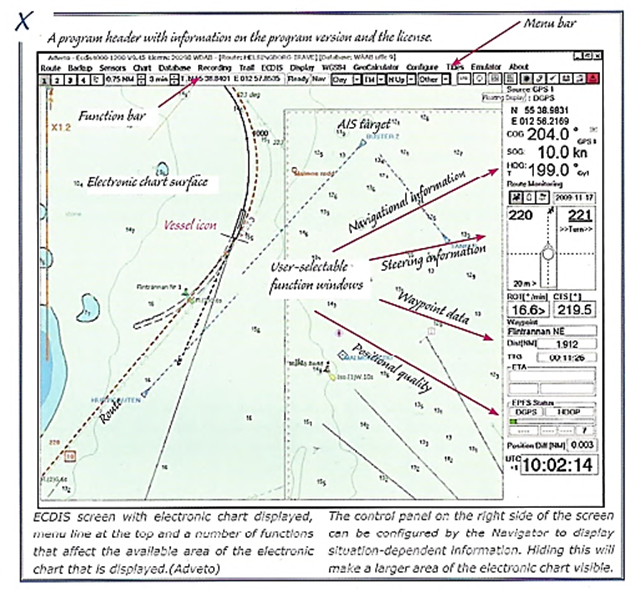
The IMO "Performance Standards" for ECDIS specifies ECDIS performance but not how to present the various functions and information. The Navigator will therefore find himself meeting manufacturer-specific screen presentations. There are, however, many common elements.
Интерфейсы для ECDIS/ECS отличаются от интерфейсов систем плоттеров несколькими по нескольким причинам. ECDIS/ECS используют одну из распространенных операционных систем для компьютеров и, как обычный компьютер, управляются меню, клавиатурой и шариком отслеживания.
Системы плоттеров имеют свои собственные операционные системы. Меню и субменю вызываются различными клавиатурами, которые, как и операционные системы и у каждого производителя свои. Сейчас все больше переходят на сенсорные экраны, но на программную совместимость это никак не виляет.
"Стандарты производительности" IMO для ECDIS определяют только технические характеристики, не касаясь схожести интерфейсов. Таким образом, навигатор столкнется с видом экрана конкретного производителя. представлять различные функции и информацию. Таким образом, Навигатор столкнется с презентациями экрана конкретного производителя. Однако есть много и общих элементов.
Navigational systems have many possible setting arrangements:
The Consistent Common Reference Point .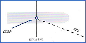 When a ship has multiple radar and GNSS antennae in different locations there is a need for refering incoming information to the same place on board. This is called the Consistent Common Reference Point (CCRP), and is a location on the ship, to which all horizontal measurements such as target range, bearing, relative speed, closest point of approach (CPA) or time to closest point of approach (TCPA) are referenced. This position is normally the wheelhouse conning position.
INS shall use the Consistent Common Reference Point for all spatial information. This enables the radar image to be correctly overlayed on the electronic chart image together with a correctly scaled ship icon during harbour manoeuvers. Specifying the CCRP is also necessary for bearings and ranges to be given correctly.
CCRP settings are usually entered during installation and may be protected by a password.
Settings for navigational work
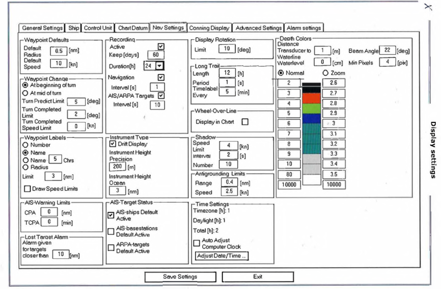
The following navigational situations may require different types of information and different screen configurations:
Furthermore, the screen configuration used for route planning has different requirements to those for route monitoring and there will be differences of opinion among Navigators as to what are the best arrangements.
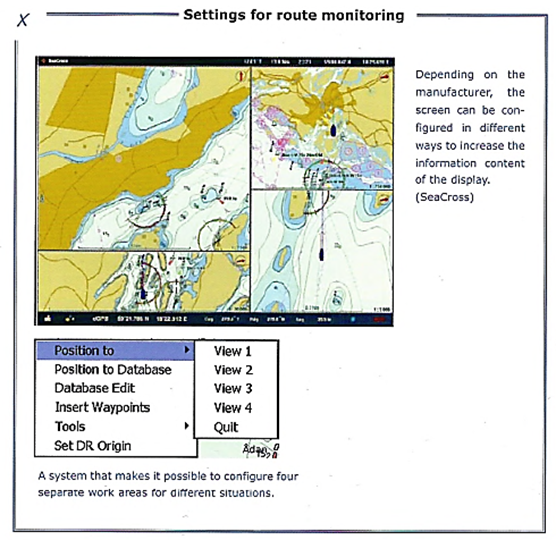
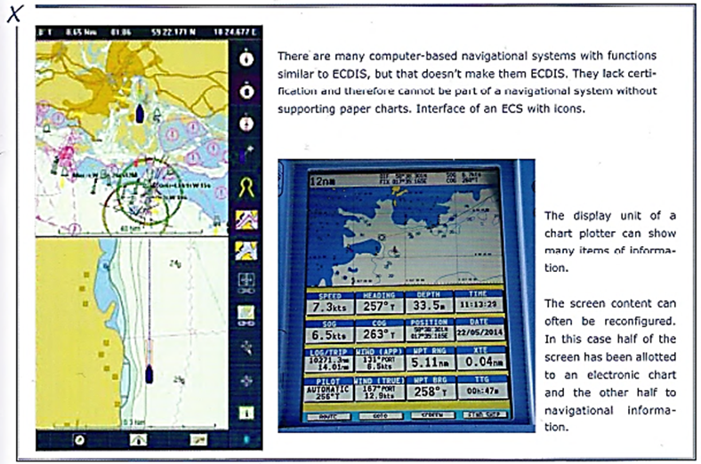
Many systems give the Navigator flexibility over both the choice of navigational data in the display and what the electronic chart shall show. This extends not only to content but also to scale and configuration of the screen area in order to meet different requirements. One difficulty with electronic charts is to combine access to an overview and detailed information. A split screen can be a good solution for this.
Plotter systems have their own operative systems. Menus and sub-menus are called up by hard and soft keypads and every manufacturer has their own system. Touch screens are becoming increasingly common.
The IMO "Performance Standards" for ECDIS specifies ECDIS performance but not how to present the various functions and information. The Navigator will therefore find himself meeting manufacturer-specific screen presentations. There are, however, many common elements.
Интерфейсы для ECDIS/ECS отличаются от интерфейсов систем плоттеров несколькими по нескольким причинам. ECDIS/ECS используют одну из распространенных операционных систем для компьютеров и, как обычный компьютер, управляются меню, клавиатурой и шариком отслеживания.
Системы плоттеров имеют свои собственные операционные системы. Меню и субменю вызываются различными клавиатурами, которые, как и операционные системы и у каждого производителя свои. Сейчас все больше переходят на сенсорные экраны, но на программную совместимость это никак не виляет.
"Стандарты производительности" IMO для ECDIS определяют только технические характеристики, не касаясь схожести интерфейсов. Таким образом, навигатор столкнется с видом экрана конкретного производителя. представлять различные функции и информацию. Таким образом, Навигатор столкнется с презентациями экрана конкретного производителя. Однако есть много и общих элементов.
Navigational systems have many possible setting arrangements:
- Configuration at installation so that the system will accept information from sensors. This kind of setting seldom needs to be changed before a repair or an enlarged installation takes place. The measurement units used are one such example. This type of setting is often protected by a password, which should be documented.
- Settings that affect the presentation. Some of these are personal choices, such as the font size for text information.
- Settings that affect navigational work. These settings adapt the display for electronic chart maintenance, route planning and navigation. The navigational requirements for the high seas, coastal routes and in an archipelago need different screen configurations. The Navigator must therefore be fluent in handling the menu system.
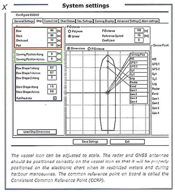
In order for ECDIS to be fully functional, information on the ship must be entered into the system, for example length, beam and turning characteristics. The ship icon can be displayed at the correct scale on large-scale electronic charts.
Settings for draught and height that were entered at the route planning stage may not be valid later, depending on the load and passage in salt or fresh water. These settings are therefore not stored permanently. Settings that are easily changed should be checked frequently.The Consistent Common Reference Point .
When a ship has multiple radar and GNSS antennae in different locations there is a need for refering incoming information to the same place on board. This is called the Consistent Common Reference Point (CCRP), and is a location on the ship, to which all horizontal measurements such as target range, bearing, relative speed, closest point of approach (CPA) or time to closest point of approach (TCPA) are referenced. This position is normally the wheelhouse conning position.INS shall use the Consistent Common Reference Point for all spatial information. This enables the radar image to be correctly overlayed on the electronic chart image together with a correctly scaled ship icon during harbour manoeuvers. Specifying the CCRP is also necessary for bearings and ranges to be given correctly.
CCRP settings are usually entered during installation and may be protected by a password.
Settings for navigational work
The following navigational situations may require different types of information and different screen configurations:
- Oceanic navigation
- Coastal navigation
- Navigation in restricted waters, archipelagos and rivers
- Harbour manoeuvers
Furthermore, the screen configuration used for route planning has different requirements to those for route monitoring and there will be differences of opinion among Navigators as to what are the best arrangements.
Many systems give the Navigator flexibility over both the choice of navigational data in the display and what the electronic chart shall show. This extends not only to content but also to scale and configuration of the screen area in order to meet different requirements. One difficulty with electronic charts is to combine access to an overview and detailed information. A split screen can be a good solution for this.
A number of reports expressed suspicions that incorrect settings or other management of the interface may have hadsignificance for an accident but it is usually difficult to identify this kind of situation at a later date.