 +7 (812) 4-673-673
JLN-652

Certificate:
-
RMRS
Available for order
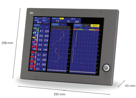
JLN-652 - Doppler lag produced by the JRC, combines a compact design, a variety of functions and features, allowing you to quickly and accurately measure the speed and make the flow of data. In Lag JLN-652 screen, you can view the current direction and speed in real time, thanks to the 3D mode scroll. JLN-652 allows easy and convenient way to carry out all the operations using the keyboard on which the keys for quick access to the menu in one click.
JLN-652 allows you to keep track of the bottom to a depth of 250 m ^ 2, by measuring the direction and speed relative to the ground. If the depth is too great, the JLN-652 automatically switches to lag tracking mode via GPS. JLN-652 is also equipped with an alarm, which in case of alarm displays a message that allows the user to take action to rectify the fault. In memory JLN-652 can be saved up to 1000 points of the current route. Lag JLN-652 is certified by the Russian Maritime Register of Shipping.
Specifications:
- The frequency of 240 kHz
- Resolution 1024 x 768 pixels (XGA)
- Power supply 21.6 to 31.2V DC (100 to 230 V AC optional)
- Power consumption: <270VA
- Ambient conditions Temperature: -15 to 55 ° C, relative humidity: 0% to 93% non-condensing
- current measurement
- The current speed range from 0 to 10 kN (to within ± 2% rms or 0.2 kN, depending on the highest)
- Displays the current direction of the whole environment of 360 ° and the numeric value with 32 reference points
- Current Maximum layers: 50 layers (numerical readout of 5 pre-selected layers)
- Current depth of 2 to 30 m (in shallow sea mode), from 12 to 100 m (Standard), maximum: 2001 to goda
- m
- The bottom of the measuring Minimum depth: 5 m, maximum depth: 3501
- m
- 2 installation depth of 500 m
- Current link Doppler or GPS
- Measuring the speed of the vessel
- Fore / aft range from -10 to 40 kN (accuracy ± 1% RMS or 0.1 kN, depending on the highest)
- Port / starboard range from -10 to 10 kN (accuracy ± 1% RMS or 0.1 kN, depending on the highest)
- Measuring speed Ground speed: from 5 to 250 m, maximum: up to 3501
- m
- water velocity: 10 m (both displays simultaneously)
- The distance run from 0 to 99,999.99 NM (with an accuracy of ± 1% RMS or 0.1 kN, depending on the highest)
- Automatic tracking of the lower shift Yes
- Main factors
- amperage measurement function, the speed of the ship, depth, fish finder, track plotting, display graphics, the display profile
- self-diagnostics, alarm function
- Display Modes Current, ship, story, drawing, fish profile
- Alarms Current speed, boat speed, depth, trip timer, water temperature, wind speed
- conjugation
- NMEA input (v1.5 to 3.01) Bearing: HDT, VHW, HDM, HDG, THS; Speed; RMC, VTG;
- Lat / Lon: RMC, GGA, GLL; Temperature: MTW; Wind: MMP, MWV
- NMEA Out (v1.5 to 3.01) VDVBW, VDVLW, VDVHW, VDDBT, VDDPT, VDCUR, PJRCL (ship speed and tidal current)
- External blocking the trigger input of the receiver via an external trigger transmission
- Distance 4x pulse output magazine (200 pulses / NM)
- JRC JRC Output format (for the current output data)
 15.02.2017
Replacement of the magnetron on the radar
15.02.2017
Replacement of the magnetron on the radar
Instructions for replacing the magnetron during the voyage using the example of the JRC radar.