 +7 (812) 4-673-673
MaxSea-NavNet PC software
MaxSea-NavNet PC software
MaxSea-NavNet PC software provides the possibility of increased efficiency at sea using a smooth transition from map to map, the imposition of advance weather forecasts, three-dimensional display of the bottom in real time (Personal bathymetric generator) and much more:
 Sharing all navigation data on the NavNet vx2 network
- Complete NavNet vx2 system management
- Full control of the NavNet display, in particular the range of the radar, gain / VRA, etc.
- Overlapping radar targets on a map (a course sensor is needed)
- Smooth movement on electronic maps and laying using raster, vector and three-dimensional bathymetric maps
- Distinguishing functions of the ground in 2D / 3D modes, which allows you to superimpose data on unevenness and hardness of the bottom, as well as data of its classification on two- / three-dimensional maps MaxSea
- Constant updating of three-dimensional maps using a personal bathymetric generator (PBG) and a network sounder
- The possibility of tracking the radar targets of ARPA
- Compatibility with AIS transponder ** AIS receiver must be connected.
MaxSea-NavNet software is available in three versions:
- MaxSea-NavNet Commander
- MaxSea-NavNet Explorer
- MaxSea-NavNet Professional
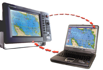 With MaxSea-NavNet, network information NavNet vx2 is transmitted directly to the PC. The split screen displays radar targets overlaid on the map, a depth profile with a forward view and a three-dimensional view of the bottom.
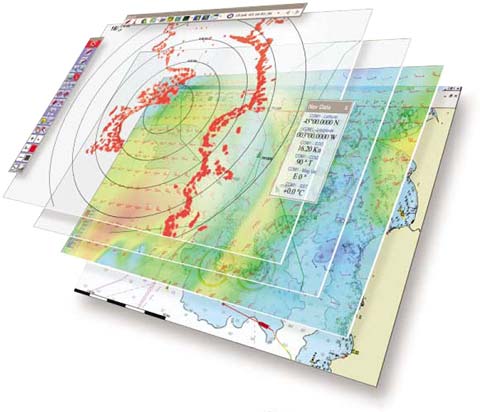
A unique overlay system optimizes the visualization of data
The MaxSea-NavNet multiple overlay system on the screen creates a combination of different layers of information. Each layer contains different types of data, for example, trajectories, labels, hazards, wrecks, ports, currents, water temperature, etc.
You can turn on or turn off the display of each layer by mouse click, depending on what you need at the moment, removing irrelevant information and leaving only the objects of interest.
An additional personal bathymetric generator (PBG) shows clear contours of the bottom
When connected to the network sounder and GPS, the MaxSea-NavNet PBG generator locks the location and depth as the vessel moves, which allows you to create the most accurate 2D and 3D maps in real time. MaxSea- NavNet PBG is activated with a single click of the mouse, after which an amazing "live" bottom image in 2D or 3D format is displayed.
System requirements:
- Windows 2000 or XP
- Processor 1 GHz (1.5 GHz or more recommended)
- CD-ROM drive - for installing MaxSea-NavNet software
- Parallel or USB port - to connect the NavNet 3D system and the security key (hardware key)
- 20 GB of hard disk space (40 GB recommended)
- Video card: 32 MB (64 MB recommended), compatible with DirectX 9
- Networking capabilities: Ethernet 10/100 Base-T
Иностранный язык: en